Showing posts with label geodynamics. Show all posts

Thursday, 24 May 2012

Thursday video: Difference between crust and lithosphere

14 comments
Mechanical and chemical division of Earth.
Today's video deals with a topic of tectonics: the difference between crust and lithosphere. Many people mix these two things, and hopefully this video will help you to know when to talk about crust, and when to talk about lithosphere. It is very easy, but many people just don't pay enough atttention!

This video has been produced by Khan Academy, a non-profit organisation which aims "to provide a high education to anyone, anywhere". A really good initiative. Visit their site here, where you will find many resources of virtually anything!: www.khanacademy.org 

Enjoy!

Source: http://www.youtube.com/watch?v=f2BWsPVN7c4

Thursday, 3 May 2012

Thursday video: Debunking expanding Earth

17 comments
Where the mass comes from?
Have you ever heard about the "Expading Earth" hypothesis? Have you ever watched or even listened to the videos posted in YouTube by comic artist Neal Adams? Well, then you may be as amazed as I am by the imagination and persistence of this man.

Neil defends the idea, and even calls it "theory" (sorry Neil, but yours is not a theory... check out in some dictionary what is the scientific meaning of theory), that our planet Earth is in constant expansion, and there is a conspirancy and cover up of these "facts". Well... this is funny up to some point. The truth is that this is quite sad, because YouTube is a website that many kids use and it end up spreading this unscientific positions. But, how a 12 year old kid may know that?

If you have ever had to answer to some friend why the Earth doesn't grow, if you have ever found a person who thinks that Neil* is right and the rest of the world is wrong... Well, watch this video, produced by "potholer54", an Australian journalist with many interesting videos. Send it to your friends, to the ones who think science is about covering facts!

Have fun... and I will try to post something more serious next Thursday. Or perhaps we will discuss why Earth is not flat :0)


*Well, he and a few more: http://en.wikipedia.org/wiki/Expanding_Earth

Tuesday, 28 February 2012

Extensional grabens in our shrinking Moon

6 comments
The largest of the observed grabens with the
 Narrow Angle Camera (NAC) of the LRO spacecraft. 
It is about 500 m wide, and nearly 20 m deep. 
(Credit: NASA/Goddard /
 Arizona State University/Smithsonian Institution)
Who has not read a thousand times that our Moon is a death body without any activity? Well, it turns to be the opposite: The Moon has been active at least until very recent times, and very likely this activity continues now.

Lunar Reconnaissance Orbiter (LRO) spacecraft has obtained images of the surface of our satellite where extensional faults are clearly visible. NASA estimates that this faults are not older than 150 million years, which is pretty young for what we expected to be the lunar tectonics.

Two years ago, the Lunar Reconnaissance Orbiter mission also detected other young geological features, which where interpretd as compressional uplifts. It was said, at that time, that the Moon is shriking. But the identification of extensional faults shows that this shrinking (due to thermal contractions) is not homogeneus everywhere.


But why not listening directly to Tom Watters from the Smithsonian Institution? (You can also active the subtitles!):


Diagram of formation of a graben with two bounding faults (Credit: Arizona State University/Smithsonian Institution)

Read more here: http://www.nasa.gov/mission_pages/LRO/news/lunar-graben.html


Monday, 19 September 2011

6.9Mw earthquake in India, Nepal and Tibet

0 comments
A 6.9 Mw earthquake hast struck India, Nepal and Tibet, causing at least 18 casualties. Much damage has occurred, and landslides have been triggered by the seismic event, blocking remote regions and breaking communication with the most affected areas.

Early calculations locate the hypocentre at 19.7 km depth, underneath the Sikkim region of India. The focal mechanism solution indicates a likely strike-slip movement in a fault which doesn't seem to be directly related with the India-Eurasia thrusting.
This earthquake is related with the convergence of the Indian subcontinent moving towards Eurasia, a phenomenon that causes the uplift of the Himalayan range.

More info at:
http://www.bbc.co.uk/news/world-south-asia-14967812
http://www.bbc.co.uk/news/world-south-asia-14967857
http://earthquake.usgs.gov/earthquakes/eqinthenews/2011/usc0005wg6/#summary

Monday, 22 August 2011

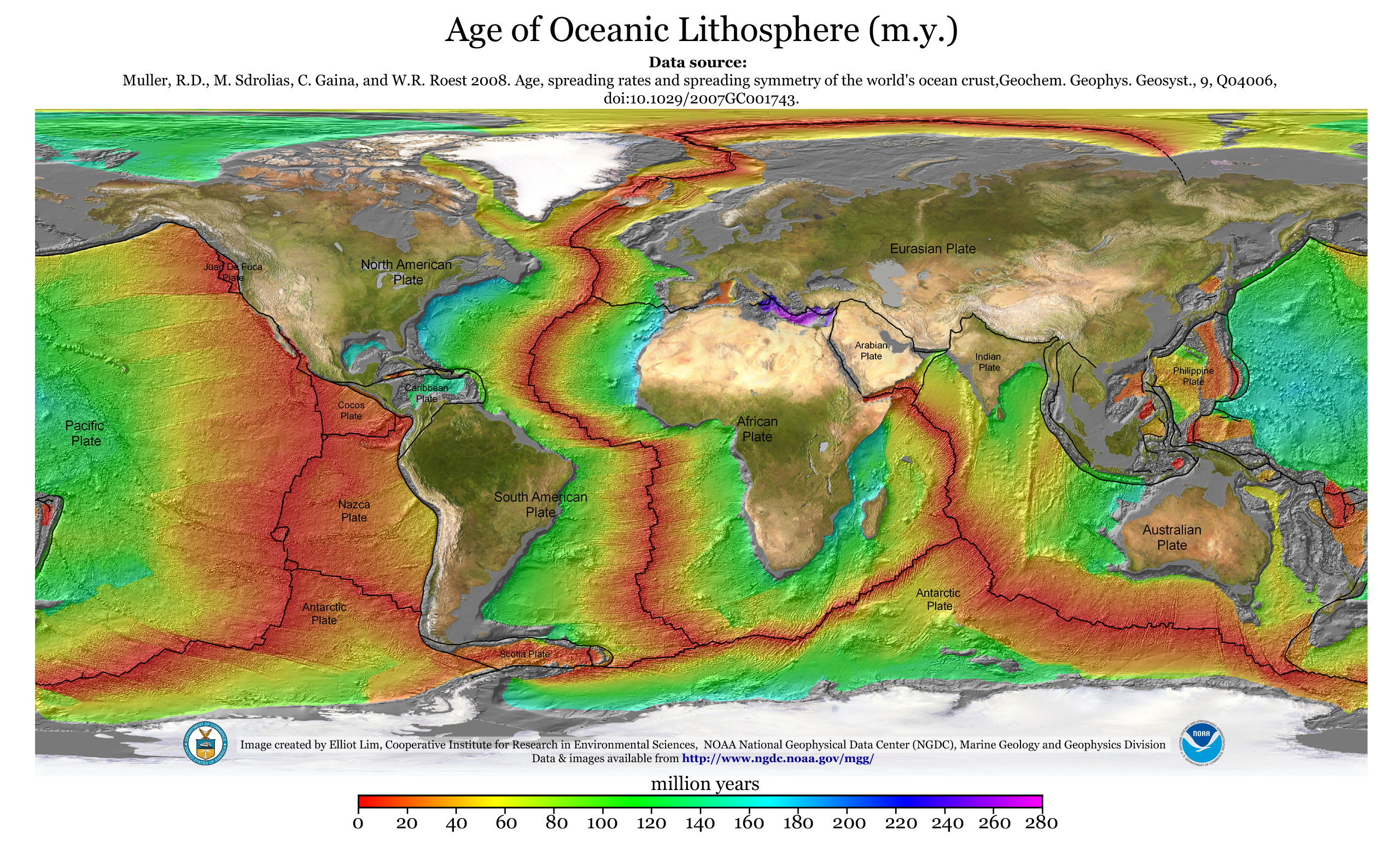
Age of the oceanic lithosphere

0 comments
Just a short note... I found the other day (or I should say, refound, as I have used it many times in the last years) this image from

Cool, isn't it? :-) And it makes a great desktop background!


http://www.ngdc.noaa.gov/mgg/ocean_age/data/2008/ngdc-generated_images/whole_world/2008_age_of_oceans_plates.jpg

You can find more here. http://www.ngdc.noaa.gov/mgg/ocean_age/
Enjoy!

Saturday, 30 July 2011

Earthquake triggers research in Pacific Ocean

5 comments
The rig floor of the JOIDES Resolution scientific drilling vessel. (Credit: IODP)
The Integrated Ocean Drilling Program (IODP) is an international marine research program that explores Earth's history and structure recorded in seafloor sediments and rocks, and monitors subseafloor environments. IODP builds upon the earlier successes of the Deep Sea Drilling Project (DSDP) and Ocean Drilling Program (ODP), which revolutionized our view of Earth history and global processes through ocean basin exploration.

Geology.com publishes a story about the Costa Rica Seismogenesis Project (CRISP) expedition carried out by the scientific drilling vessel JOIDES Resolution, and the nearly 1,500 m of sediments collected from the ocean floor off the coast of Costa Rica, revealing records of some two million years of tectonic activity along a seismic plate boundary.

You can find more on this story in the original sources:

http://geology.com/press-release/pacific-earthquake-triggers/
http://iodp.org/index.php?option=com_content&task=view&id=577&Itemid=1237

The CRISP research site is located 174 km (108 miles) off Costa Rica. IODP image.

Wednesday, 16 March 2011

Japan has moved

4 comments
Many newspapers and websites have published during the last days that "the Earthquake has moved Japan". Interestingly, most of journalists focus on the lateral movement, but forget the vertical displacement.

More and more data comes to light after the massive earthquake in Japan last week. As Callan Bentley points out in his blog, the vertical component of the displacement vector field shows a general subsidence in all the East coast of Honshu (Japan's main island). The maximum subsidence is 75 cm, while the horizontal displacement has been of up to ca. 4.4 m (eastwards).
At first sight, it could look awkward, as the affected part of Japan is in the Okhotsk Plate, which is the overriding plate, while the Pacific plate is the subsiding element. Shouldn't the overriding plate uplift, instead of subside? Let's analyse it more in detail.
A megathrust fault is the tectonic boundary between a subsiding plate and an overriding plate. Megathrust faults are the causing element of the majority of most powerful earthquakes in the Earth. Probably, the most famous megathrust is beneath Cascadia in North America, and you can find most of the information you need about that in this great site: Giant earquakes of the Pacific NW.
Coming back to Japan, which is part of the Eurasian plate, it overrides the Pacific plate over a megathrust. This is the fault that, with its slip due to elastic rebound, caused the 9.0 Mw earthquake some days ago. But of course, the slip occurs suddenly, after accumulating energy for certain time.
As the following figure shows (taken from here), the overriding plate develops a bulge -due to strain build-up- when the upper plate locks over the subducting plate. Behaving elastically, the bulge grows as shortening continues, and the overriding plate continues accumulating strain in the bulge area. At some moment, the contraction is so strong that it exceedes the hold of friction along the fault, and an earthquake is triggered. The strain build-up relaxes, and the previoulsy uplifted region subsides. The cycle starts all over again.

This is what has happened in Japan. An example may be to imagine ourselves pushing a mat, with our feet, against another mat. One of them will form a fold in the rim, until its resistance is broken, it slips over the "subsiding" mat, and the fold disappears.
In 1700, that happened in Cascadia (http://blog.lib.umn.edu/stgeorge/geog5426/2010/11/13/Jacoby%20Geology/201997.pdf), when a massive earthquake caused the subsidence of a region, where many trees drowned and just a handful of them survived... for telling us through their ring what happend with the topographic base level. (Photo from here)
NASA has published two MODIS images, showing the coastline in Sendai before and after the eartquake. It is still early to estimate the new coastline, as in the images of this week many lands near the coastline are still flooded by the tsunami wave, and will probably not be submerged in the near future.

Before (26th Feb. 2011)After (12th March 2011)

Monday, 14 March 2011

Supersite for Sendai-Oki Earthquake

2 comments
Supersite is an initiative of the geohazard scientific community, providing access to remotely sensed and in situ geophysical data related with highly hazardous sites in our planet Find out more here.
It has already a dedicated website to the 8.9-9.0 Mw Japan earthquake, which is being now called Sendai-Oki earthquake, and the amount of scientific data is truly impressive. From different focal mechanism solutions to motion vector fields as measured with GPS:

I'd like to hightlight the following:
Preliminary GPS displacement data provided by the ARIA team at JPL (vector fields provided as ASCII data): http://supersites.earthobservations.org/sendai.php#Sat5
Horizontal displacement based on estimated poistion of GEONET stations: http://supersites.earthobservations.org/ARIA_japan_co_postseismic.pdf

Note that the Supersite is regularly updated, so don't forget to revisit it.

Shorter days caused by earthquakes?

8 comments
The powerful earthquake of 11th of March in the island of Honsu (Japan) has shortened the day length in 1.8 µs (microseconds, or millionths of a second), has declared Richard Gross from NASA's JPL in Pasadena, CA (USA). Gross has calculated the change in inertia moment, after the deadly earthquake has changed the distribution of Earth's mass.
The massive earthquake has also affected the geometric axis of our planet, which could have been moved up to 17 cm.
"In theory, anything that redistributes the Earth's mass will change the Earth's rotation," Gross said. "So in principle the smaller aftershocks will also have an effect on the Earth's rotation. But since the aftershocks are smaller their effect will also be smaller."
Gross had also calculated in the past displacements of our axis and variations of our day length, following large earthquakes in Sumatra and Chile.
My question is: Does this actually happened? Do this calculation involve astronomical measures that certify the change, and if so, its magnitude? Is this earthquake strong enough to vary the angular inertia of the planet?
Any insight? Please, comment.
You can read the full story at SPACE.com,

Friday, 11 March 2011

Are there more earthquakes in our days? Is the end of the world here?

330 comments
Not even 24 hours have passed since the deadly 8.9 Mw earthquake in Honshu, Japan, and already conspiranoics, cranks and even some broadcasters are opening the door of the panic room in the internet: Are we having more earthquakes now than some years ago? Is the end of the world approaching? Is Gaia trying to get rid of us?

The answer to all these questions is a big NO.

As most of people know, an earthquake is the sudden slip on a fault, and the consequent instantaneous emision of energy in the shape of seismic waves that was previously accumulated in a fault. There are many reasons for that, and many different types of faults in many different parts of the world, but the Ring of Fire in the Pacific is certainly one of th most hazardous areas in our planet in terms of seismicity.

The USGS, even though is the national geological survey for the USA, registers earthquakes in all the planet and publishes statistics about them. So, are earthquakes from frequent lately? The answer is in the facts, as usual in this topics.

Take a look to these graphs, where the number of earthquakes, classified by number and per year, is depicted. It is clear and obvious that the frequence of quakes of magnitud over 7.0 stays pretty constant:

But, we may think: "Every year it seems that more people die because of natural catastrophes". Well, it may seem like that until we take a look to the statistics, and then this idea simply vanishes.
What happens is a mixture of not so natural phenomena.
  • In first place, we have instant communications around the whole of the planet. And this didn't existed before. We switch on the TV when we get up, and we see in the news in UK or USA or Finland what is happening at the moment in Japan, tens of thousands of kilometres away.
  • Secondly, the network of seismograph stations is more complete every year, and therefore the amount of earthquakes located is higher (and also the amount of smaller earthquakes detected. In 1931 there were 350 seismograph stations in the world. Today, there are more than 8000. Of course, that information is easily available and fills the media constantly. It is far more easy now to report an earthquake of 5.0 or 6.0 Mw, than it was in 1985. Note that the graphs DO actually show an increase, but this increase is more probably related to the number of registered earthquakes, and not to the actual seismic activity.
  • In the last years, big quakes have occurred in populated areas, being more relevant. Sumatra, Haiti, Chile, Japan... But do we care when an earthquake happens in the Aleutians? Hazard is not synonym of risk! Risk involves exposure of human lives, of economically valuable places.
And of course, the Mayans didn't predict anything!

Source of the graphs: http://earthquake.usgs.gov/earthquakes/eqarchives/year/graphs.php

Tuesday, 1 February 2011

"Dynamic Topography - a key surface record of deep Earth processes" conference

1 comments
(From the Geo-Tectonics list)

Conference to be held at Burlington House, September 1-2, 2011
(GeolSoc Lecture Theatre; Piccadilly, London W1J 0BG)

Meeting arranged by the Geological Society, British Geophysical Association and Royal Astronomical Society, and  bringing together geologists, geomorphologists and geophysicists seeking to understand how processes operating within the mantle interact with those acting on the surface to shape the Earth’s topography and control sediment and geochemical flux.
Keynote speakers:
Michael Gurnis, Seismological Laboratory, California Institute of Technology, USA
Alessandro Forte, Université du Québec à Montréal,
Canada Invited speakers:
Carolina Lithogow-Bertelloni, University of College London, UK
Jean Braun, Universite Joseph Fourier, France
Hans-Peter Bunge, Ludwig-Maximillians Universitat Munich, Germany
Evgene Burov, Institut des Sciences de la Terre de Paris, France
Reiner Rummel, Technische Universitat Munich, Germany
Tony Watts, University of Oxford, UK
Nicky White, University of Cambridge, UK
Conveners:
Roderick Brown, University of Glasgow, UK
Patience Cowie, University of Bergen, Norway
Stewart Fishwick, University of Leicester, UK
Gregory Houseman, University of Leeds, UK
Michael Kendall, University of Bristol, UK
Nicky White, University of Cambridge, UK


Further information:

Georgina Worrall
The Geological Society, Burlington House, Piccadilly, London W1J 0BG

Tuesday, 11 May 2010

Link of the month: Patrice Rey's website

1 comments
In the past weeks I haven't had any time to look for new and attractive websites to present them here, so my selection of "website of the month" is a bit delayed.

But never is to late, as they say, and I have in my bookmarks a very interesting link that you may find useful for yourself or your students, if that is the case: the website of Dr. Patrice Rey, from the School of Geosciences of the University of Sidney.

I guess the website is not very updated, at least in some sections, and I haven't found the way to access the following sections from his homepage, but nevermind, as here you have the direct link to them. He has two teaching modules, organised in the style of an online presentation, with very clear explanations and beautiful graphics:


"Module 1" focusses on thermo-mechanics of lithospheric deformation, with the following sections: Course Outlines, Driving Forces, Isostasy & Gravitational Forces, Heat and Temperature, Continental Geotherms, Thermal Consequences of Lithospheric Deformation, Rheology and Lithospheric Strength y References.

"Module 2" focusses on tectonics, with the following chapters: Course Outlines, Introduction, Finite Strain Analysis, Convergence & Shortening, Divergence & Extension, Gravity Driven Deformation, Transcurrent Tectonics, Finite Strain Field Interferences and References.

So, run to visit the website, and write Patrice if you like it. Surely he likes to see that his online work is not only useful for his students!


_

Monday, 6 April 2009

Mw 6.3 Earthquake in Italy

1 comments
We got up this morning with the terrible news from Italy, where last night an earthquake affected significantly the location of L’Aquila in the Central Apennines region resulting in more than 90 killed (so far, at 14.00 GMT, and surely the number will increase in the next hours).

The Apennines are an accretionary wedge formed as consequence of the subduction of the Adriatic microplates under Italy from east to west, whilst from the south to the north the convergence of Africa against Europe builds the Alpine orogen and opening the Tyrrhenian sea to the west of the Italic peninsula.  

I won’t extend much in this entry; you can read better and more updated information in the news:


Sadly an Italian geophysicist predicted the event –kind of–. We cannot rely on predictions. We cannot expect –yet– to trust correlations between indirect measurements and seismic phenomena. What we can do?

What we can do as geologist is help the authorities educating people, promoting the knowledge of geohazards and how to behave in the case of an Earthquake. Authorities have in their hands the power of approve correct standards for construction. A 6.3 earthquake shouldn’t have caused any fatality in a rich country like Italy. Why it has been like that? Seismicity in the Central Apennines is not new. Historic earthquakes include the one  of 1997 (Mw 6.0) which includen in a period of 2 months several M5.0 events (the Umbria-Marche seimic sequence).

Our support to the people in despair for this earthquake.

(Later I will update this article with some images and corrections... I am sending this from my email!)


Wednesday, 25 March 2009

Tonga and bad science

1 comments
In the recent weeks we have witnessed through the media the eruption of the Tonga submarine volcano reaching the oceanic surface. Spectacular images make us feel small in this wonderful planet. The volcano is emerging day after day and, as reported by Associated Press, it is located at 10 km from the main island, Tongatapu, in a cluster of nearly 60 other volcanoes.

A few days after after the volcano got protagonism, the media also informed of a relevant earthquake in the area, happened on the March 19th, 2009. A 7.6 magnitude earthquake shaked the conctact between the Pacific, also in the vicinity of Tonga.

Well. No. Not really. I mean, yes, it happened, but not in the "vicinity of Tonga". It happened 260 km of the location of the volcano. Anyone with a slight knowledge of geology would think: "Yeah, they are close, relatively, but surely not related at all".


This thought didn't pass through the mind of the responsible of choosing the title of the news in the BBC website...: Quake may have caused eruption. Well, why do they choose this title if the video doesn't make any connection between both events? Very few people would have seen the video (hey, it's science, not a celebrity in Cannes), and most of the readers have kept in mind just that: The earthquake and the volcano may be related.

It is hardly explainable how an earthquake in such a tectonic framework (an oceanic convergence) can cause, or trigger, or affect a volcano 250-300 km away. Both phenomena are perfectly understandable if we take them independently. So, why the story in the news? Possibly is easier to sell the story like that.

I remember how difficult is to explain people how two events can happen at the same time but be absolutely independent: "Sorry, are you saying that the tsunami in Sumatra is not related with global warming? but... surely is related. We destroy our planet! And anyway, you work with satellites, you haven't been in the field". Argh.

Anyway, the good news is that there is not any material harm, and general news are talking about geology. Woohoo.

(Reading about the Tonga volcano and the earthquake I got know the blog of Maria Brumm, "Green Gabro". Take a look, is well worth doing it)