Monday 20 September 2010

DRT 2011 in Oviedo, Spain.

0 comments
This is a message sent to the Geo-tectonics list by Sergio Llana Fúnez on behalf of the organising committee of the DRT 2011. Having done my degree in the University of Oviedo, it always catches my eye when they organise an international event (like the YORSGET in 2008, on young researchers in structural geology).


This is an early announcement for the next Deformation mechanisms, Rheology and Tectonics (DRT) meeting that will be hosted here at 
Oviedo University from the 31st of August to the 2nd of September 2011. We already have a website


where you can find preliminary information about the meeting. It will be updated in the coming months as we approach the meeting.

The DRT meetings are hosted every two years by different European Universities, the tradition was started by Prof. HJ Zwart, who 
organised the first meeting in Leiden in 1976. Spanish geology benefitted substantially from the geological mapping the group of 
Leiden did in various parts of the Iberian Peninsula (Galicia, Cantabrian Mountains, Pyrenees) and partly for that reason in the last 
meeting in Liverpool we proposed to bring DRT to Oviedo. The range of topics and the focus of the meeting towards deformation processes, 
regardless of the scale (micro to orogenic), will remain in Oviedo in 2011.

Oviedo is quite conveniently located to study the geology of orogenic belts (see geological map in the website), for that reason there is a 
plan to run a fieldtrip across the Variscan Orogen. It is likely that the field trip will be split into two separating the internal parts 
from the external parts of the orogen, before and after the conference.

Later on in the year we will send the first circular with more details about the conference.

Please, for any suggestions, sponsors, do not hesitate to contact us. We hope to see you all here in a year.

Best regards,

Sergio Llana-Funez
Marco A. López
Francisco J. Fernández
Miguel Gutiérrez-Medina

Departamento de Geología
Universidad de Oviedo

drt2011@geol.uniovi.es

Friday 3 September 2010

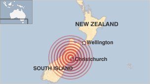
Strong earthquake hits New Zealand

0 comments
A 7.0 earthquake has shaken New Zealand today, two hours ago. More information at BBC.

From the USGS.gov website:
New Zealand earthquake occurred as a result of strike-slip faulting within the crust of the Pacific plate, near the eastern foothills of the Southern Alps at the western edge of the Canterbury Plains. The earthquake struck approximately 50 km to the west-northwest of Christchurch, the largest population center in the region, and about 80-90 km to the south and east of the current expression of the Australia:Pacific plate boundary through the island (the Alpine and Hope Faults). The earthquake, though removed from the plate boundary itself, likely reflects right-lateral motion on one of a number of regional faults related to the overall relative motion of these plates and may be related to the overall southern propagation of the Marlborough fault system in recent geologic time.
Today's earthquake occurred approximately 50 km to the southeast of a M7.1, surface-rupturing event in Authur's Pass, on March 9th, 1929, which caused 17 fatalities. More recently, two earthquakes of M6.7 and M5.9 occurred in June 1994 approximately 40 km to the northwest of today's event, but did not cause any known fatalities or significant damage.
http://earthquake.usgs.gov/earthquakes/eqinthenews/2010/us2010atbj/

BGS image bank

0 comments
When I need an image for illustrating a report with a generic example, I usually go to Flickr and look for images without copyright (or with a copyright that allows me to use it). You can actually look for the same at  http://www.creativecommons.com

But perhaps the best option is to look directly for images tagged and classified by geologist! The British Geological Survey (BGS) has an awesome collection of images available online. This images are free to use for education, teaching, preparation and examination purposes, and surely will be welcome by many of you.


Good search!