Thursday 27 October 2011

Visible Geology: a visualisation tool

14 comments
Rowan Cockett's Visible Geology is an interactive tool for visualising geological structures, ideal for teaching and also for self-study. Visible Geology is highly interactive and web-based, so the only thing you need for using it is a HTML5 compatible browser (basically, not IE). I am really impressed by this simple but complete application.

http://visible-geology.appspot.com/ 

In Visible Geology you can create block diagrams for illustrating bedding, faulting, folding and intrusions (dykes).You can keep this blocks as a simple cube, or what is really nice, is that you can modify the topography. You can model top surface of the cube with a couple of easy options, drawing contour lines or selecting predefined patterns (like valleys, slopes, mountain tops, etc.).

But it doesn't end there. Once you are happy with your model, you can even do cross-sections!

So, easy to use, quick (very quick), very nice results... I am just looking forward having the chance of using it for some report!

But surely the best thing is to start watching one of the available tutorials in video:


Visible Geology is in a beta status at the moment. I would suggest the following features for future versions:
- Capability for choosing bed thickness.
- Variable scale.
- Folding would improve several orders of magnitude if it would be possible to change basic parameters such as amplitude, wavelength, etc.


It is really a great program, and I am sure it will be soon widely used in education. Go to use it, go!

Thanks Rowan!


Friday 14 October 2011

Björk, Biophilia and plate tectonics

5 comments
Did you ever imagine I would write about music here? No, of course not. And that was because Björk didn't compose before her new "Biophilia" album, a masterpiece of modern music that aims to mix music, technology and science. Actually, the album has been released as a traditional CD but also as an application for your smartphone. I will leave the review and explanation of the album to other people: CultureLab interview with Björk. (Yes! Bjork in "New Scientist"!).

So, why I write about "Biophilia" in this blog, afterall? Well, first, becuase I love this album and anything that comes out of Björk's mind, and second, because the 8th track of the album deals with... yes, plate tectonics! "Mutual Core" is the 9th track of the album. A song with absolutely explicit scientific lyrics, full of metaphors that we, geologists, will love ("As fast as your finger nails grow/the Atlantic ridge drifts","My Eurasian plate subsumed,/ Forming a mutual core"). I find it absolutely hypnoptic, beautiful and, why not, magnificient.


"Mutual Core"

I shuffle around the tectonic plates in my chest.

You know I gave it all,
Try to match our continents
To change seasonal shift,
To form a mutual core.

As fast as your fingernail grows,
The Atlantic ridge drifts
To counteract distance.

You know I gave it all,
Can you hear the effort of the magnetic strife?
Shuffling of columns
To form a mutual core.

This eruption undoes stagnation.
You didn't know i had it in me,
Withheld your love, an unspent capsule.
I didn't know you had it in you,
You hid the key to our continuity.
I didn't know you had it in you.
This eruption undoes stagnation.
You didn't know, you didn't know.

What you resist persists, nuance makes heat
To counteract distance
I know you gave it all,
Offered me harmony if things were done your way.
My Eurasian plate subsumed,
Forming a mutual core

This eruption undoes stagnation.
You didn't know I had it in me,
Withheld your love, an unspent capsule.
I didn't know you had it in you.
This eruption undoes stagnation
You didn't know i had it in me
This eruption undoes stagnation
You didn't know, you didn't know”

Sunday 2 October 2011

DRT2011 fieldtrips - Photoalbum

5 comments
DRT2011 Preconference fieldtrip 1. Porma mélangeDRT2011 Preconference fieldtrip 2. Porma mélange.DRT2011 Preconference fieldtrip 3. Porma mélange.DRT2011 Preconference fieldtrip 4. Porma mélange.DRT2011 Preconference fieldtrip 7. Porma mélange..DRT2011 Preconference fieldtrip 8. Porma mélange.
DRT2011 Preconference fieldtrip 5. Porma mélange.DRT2011 Preconference fieldtrip 10. Porma mélange.DRT2011 Preconference fieldtrip 9. Porma mélange.DRT2011 Preconference fieldtrip 6. Porma mélange.DRT2011 Preconference fieldtrip 12. Porma mélange.DRT2011 Preconference fieldtrip 13. Porma mélange.
DRT2011 Preconference fieldtrip 14. Porma mélange.DRT2011 Preconference fieldtrip 15. Porma mélange.DRT2011 Preconference fieldtrip 16. Porma mélange.DRT2011 Preconference fieldtrip 17. Porma mélange.DRT2011 Preconference fieldtrip 18. Porma mélange.DRT2011 Preconference fieldtrip 19. Porma mélange.
DRT2011 Preconference fieldtrip 20. Porma mélange.DRT2011 Preconference fieldtrip 21. Porma mélange.DRT2011 Preconference fieldtrip 22. Porma mélange.DRT2011 Post-conference fieldtrip 1. LuarcaDRT2011 Post-conference fieldtrip 2. LuarcaDRT2011 Post-conference fieldtrip 3. Luarca
DRT2011 fieldtrips, a set on Flickr.
A the end of August and beginning of September, I attended the DRT 2011 meeting in Oviedo. This meeting included two fieldtrips, and these are the pictures I took during this great days back home in NW Spain.

I hope you enjoy them. I will be completing slowly their description, but in the meantime, if you have any question about the pictures, just let me know here in this post and I will try to answer your doubts. 

There are nearly 150 pictures, so take it easy!

J.

Thursday 22 September 2011

Tuesday 20 September 2011

Short course: Structure, permeability and fluid flow at depth in the Earth's crust

2 comments
From October 11th to 13th will take place a short course at the RWTH Aachen University on Structure, permeability and fluid flow at depth in the Earth's crust, given by Prof. Stephen Cox.

You can have more information following this link.

Monday 19 September 2011

6.9Mw earthquake in India, Nepal and Tibet

0 comments
A 6.9 Mw earthquake hast struck India, Nepal and Tibet, causing at least 18 casualties. Much damage has occurred, and landslides have been triggered by the seismic event, blocking remote regions and breaking communication with the most affected areas.

Early calculations locate the hypocentre at 19.7 km depth, underneath the Sikkim region of India. The focal mechanism solution indicates a likely strike-slip movement in a fault which doesn't seem to be directly related with the India-Eurasia thrusting.
This earthquake is related with the convergence of the Indian subcontinent moving towards Eurasia, a phenomenon that causes the uplift of the Himalayan range.

More info at:
http://www.bbc.co.uk/news/world-south-asia-14967812
http://www.bbc.co.uk/news/world-south-asia-14967857
http://earthquake.usgs.gov/earthquakes/eqinthenews/2011/usc0005wg6/#summary

Monday 22 August 2011

Age of the oceanic lithosphere

0 comments
Just a short note... I found the other day (or I should say, refound, as I have used it many times in the last years) this image from

Cool, isn't it? :-) And it makes a great desktop background!


http://www.ngdc.noaa.gov/mgg/ocean_age/data/2008/ngdc-generated_images/whole_world/2008_age_of_oceans_plates.jpg

You can find more here. http://www.ngdc.noaa.gov/mgg/ocean_age/
Enjoy!

Thursday 11 August 2011

Saturday 30 July 2011

Earthquake triggers research in Pacific Ocean

5 comments
The rig floor of the JOIDES Resolution scientific drilling vessel. (Credit: IODP)
The Integrated Ocean Drilling Program (IODP) is an international marine research program that explores Earth's history and structure recorded in seafloor sediments and rocks, and monitors subseafloor environments. IODP builds upon the earlier successes of the Deep Sea Drilling Project (DSDP) and Ocean Drilling Program (ODP), which revolutionized our view of Earth history and global processes through ocean basin exploration.

Geology.com publishes a story about the Costa Rica Seismogenesis Project (CRISP) expedition carried out by the scientific drilling vessel JOIDES Resolution, and the nearly 1,500 m of sediments collected from the ocean floor off the coast of Costa Rica, revealing records of some two million years of tectonic activity along a seismic plate boundary.

You can find more on this story in the original sources:

http://geology.com/press-release/pacific-earthquake-triggers/
http://iodp.org/index.php?option=com_content&task=view&id=577&Itemid=1237

The CRISP research site is located 174 km (108 miles) off Costa Rica. IODP image.

Thursday 7 July 2011

DRT2011 in Oviedo (and cider, chorizo, fabada...)

2 comments
As I wrote some months ago, this year's DRT meeting will take place at the end of August/beginning of September in Oviedo, capital city of Asturias (Spain). University of Oviedo organise this time the biannual reunion dedicated to deformation processes at different scales and, besides a great meeting with very interesting keynote talks, they also offer a pre- and post- fieldtrips that you shouldn't miss.
From today, July 7th to 31st, the normal registration fee is just 200€, and if you decide, and you should, register for the fieldtrips and the conference dinner, the total amount would be 595€.
You can find more information in their website: http://www.geol.uniovi.es/drt2011/Home.html
Not convinced by the talks, fieldtrips to the Variscan foreland fold and thrust belt and to the hinterland of the orogen? Not convinced by the value for money of the conference?

Then, perhaps you should go in order to try sidra (Asturian cider),

the chorizo,

and fabada! (and many, many, many more dishes that you will love!)
Not yet convinced??? Then take a look to the pictures of the YORSGET meeting organised also by the Department of Geology of University of Oviedo: http://www.unioviedo.es/YORSGET/FOTOS-CONGRESO/PHOTOGALLERIES.htm

(And yes, I miss my homeland and I will be there :-) )


:-)

Friday 1 July 2011

Louis Neel Medal to Ernie Rutter

1 comments
Prof. Ernie Rutter, from the school of Earth, atmospheric and environmental sciences of the University of Manchester, has been awarded with the Louis Néel Medal of the EGU for "his major experimental and field contributions to our fundamental understanding of the deformation behaviour of the Earth's lithosphere. In particular, his systematic laboratory studies have led to a greatly improved understanding of natural rock deformation".
The Louis Néel Medal, named after the French physicist (awarded a Nobel Prize in 1970),  has been established by the Division on Magnetism, Palaeomagnetism and Rock Physics. This medal is reserved for individuals in recognition of outstanding achievements in rock magnetism and rock physics and geomaterials.
The full story, here: http://www.egu.eu/awards-medals/awards-and-medals/award/louis-neel/teng-fong-wong0.html
Prof. Rutter: http://www.seaes.manchester.ac.uk/aboutus/staff/staffprofile.php?id=52


Monday 27 June 2011

Thrust duplexes in Devon and Galicia

5 comments
I came across the website of Jim Talbot thanks to a friend, and I would like to share with you his photographies of great examples of thrusts, duplexes and chevron folds in Devon (England) and Galicia (Spain).

(duplex with 8 horses, Widemouth Bay, Devon)


A duplex, as a reminder, is an array of thrust horses bounded by a floor thrust (i.e. sole thrust) at the base and by a roof thrust at the top (McClay, 1992).
You can also visit the homepage and enjoy the wonderful photographies, with very good examples from many places around the planet. Enjoy!

More about thrusts and duplex systems: McClay, KR, 1991, Glossary of thrust tectonics terms, in KR McClay, ed., Thrust tectonics: London, Chapman & Hall, p. 419–433

Wednesday 11 May 2011

Prophet-predicted quake in Rome

4 comments
I always say that  superstition is a tumour in our modern society. We are the best informed and educated generation ever, but we keep following irrational pulses.

Why I say that now? Because thousands of people are staying out of Rome for the next days over a rumour predicting the city devastation today, May 11 of 2011.


As the BBC story reads, these fears come after a rumour which states that seismologist Raffaele Bendandi, died in 1979, had predicted in his notes the destruction of Rome by an earthquake today. In reality, there is not any prediction about an earthquake in his notes. But, do we care? Have we lost our brains? Have we put them in stand-by?

Enter darkness, exit common sense.

Thursday 14 April 2011

Structural geology in Cabo Peñas (Asturias, Spain). Part I

7 comments
(Click on the images for enlarging them)

I live and work in London, but I was born and raised in northern Spain, in Asturias. I ResearchBlogging.orgstudied Geology in the Universidad de Oviedo, in the foothills of the Cantabrian Mountains. Such a privileged geographical and geological location means a lot of fieldwork and great landscapes.

Hercynian Massif in IberiaIn short, the NW of the Iberian Peninsula is a remanent of the doubly vergent Hercynian Orogen (see figure attached), formed during the Devonian-Carboniferous time by the collision of Laurussia (or Euramerica) with Gondwana, forming Pangaea. The attached map shows the zonation of the Hercynian Massif in Iberia: the Centroiberian Zone (in green) is the crystalline core; the Ossa-Morena Zone and the Western Asturian - Leonese Zone are the metamorphic hinterland at both sides of the axis of the orogen; and the South Portuguese Zone and the Cantabrian Zone are the external areas of the foreland fold and thrust belts. The orogen strikes in NW-SE direction in the central area of Spain, and this evolves towards NE-SW direction in the North of Spain. This rotation occurs around the Asturian Arc (which is the eastern region of the Cantabrian Zone). Figure 2 shows cross section approximately WNW-ESE, cutting through the north coast of Spain, from Galicia to Asturias.


Cross section of the Hercynian Orogen in Northern Iberia

The Narcea Antiform separates in Asturias the Western Asturian - Leonese Zone (WALZ) and the Cantabrian Zone (CZ). The WALZ is characterised by a generalised regional metamorphism, increasing westwards, whilst the CZ it is not affected by metamorphism, being deformed by thrusts and folds.

The Cape Peñas is in the Cantabrian Zone, which is portraited in t headjacent diagram. It presents a Palaeozoic succession which is partially covered by the Mesozoic-Tertiary basin, including materials from the Permo-Triassic to Neogene.

So, enough of introduction!

In this article I want to show you some pictures we did in the Bay of Llumeres. Llumeres is in the eastern side of Cabo Peñas (the most prominent cape in Asturias), and it is part of the Cantabrian Zone of the Hercinian Massif in Spain. The following cross section (looking onshore from the sea, so WNW to the right, ESE to the left), shows the general structure of the place.

Basically, in Llumeres there are very good examples of polyphase deformation: a first phase forms the recumbent and overturend folds with east vergency, and also develops a weak slaty cleavage. The second phase of deformatin forms kink-bands and crenulation cleavage.

You can find more information in the following classic paper, written in the 70's by Julivert. It is in Spanish, but I strongly recommend you to take a look at, as the diagrams are beautiful and the photographies very clear (although in B&W). Note that my first two pictures are intentionally a copycat of the first two plates of the paper!

http://www.geol.uniovi.es/TDG/Volumen08/TG08-10.PDF

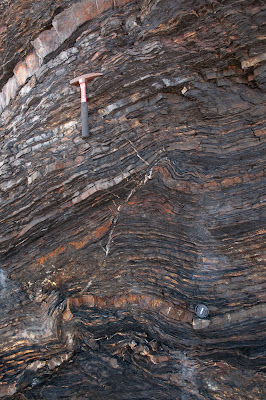
The first picture shows a beautiful overturned chevron antiform in Formigoso Shales Fm (Silurian). This fold is a first deformational phase structure. Some kink-bands (second phase) are visible. This fold is tagged as "A" in the schematic cross section presented above.


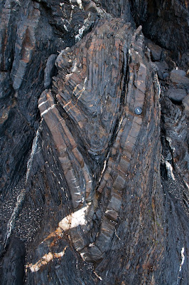
Second picture is a fantastic overturned chevron anticline. The anticline, formed during the first phase of deformation, shows very good examples of kink-bands developed during the second phase of deformation. Note also the M fold in the hinge of the structure, and the Z folds in the right flank.

The following two pictures portrait a fault-propagation fold, which, above the competent units where the cover of the camera lies, triggers the formation of a normal fault in order to accommodate the deformation:


Mineralization of pirite, afected by the second phase of deformation:


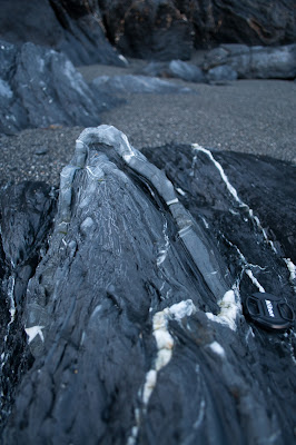
A synform, depicting the presence of quartzitic veins formed during the folding process. The synform also shows a hinge fault.

Syncline-anticline combination, with a fault cross-cutting the syncline:


And finally, a tight chevron fold, with M, and gentle S and Z parasitic folds:


Bibliography:
Manuel Julivert (1976). La estructura de la región del cabo Peñas Trabajos de Geología, 8, 203-309